
This page is designed to provide for timely and official fire information about wildland fires across the Pacific Northwest. The information is posted by the Northwest Interagency Coordination Center in partnership with Public Information Officers that work for federal, state and local fire agencies and is drawn from official sources within the wildland fire community.
Sunday, June 30, 2024
Saturday, June 29, 2024
Friday, June 28, 2024
Thursday, June 27, 2024
6/27/2024 Tucker and Yellow Peak Fires Update
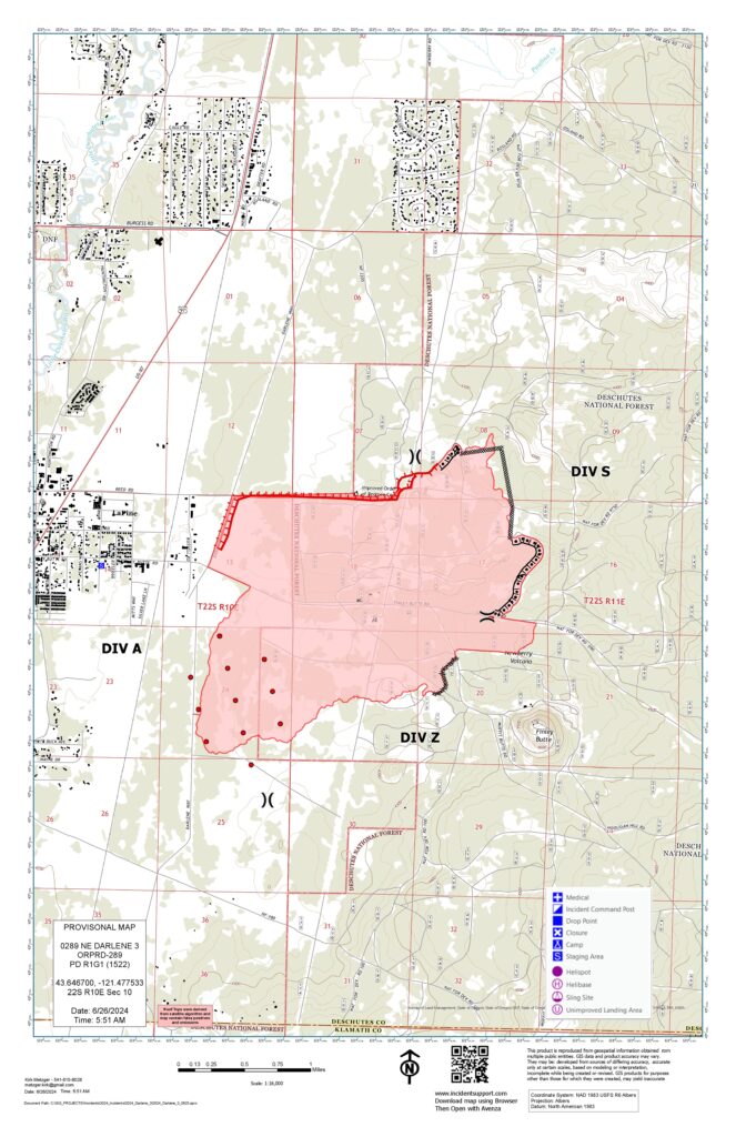
6/27/2024 Darlene 3 Fire Update
June 27, 2024 10:00am
Central Oregon — After a day of heavy fire activity, firefighters worked through the night on the Darlene 3 Fire to conduct firing operations and complete containment lines. The Central Oregon Type 3 team remains in unified command with Oregon State Fire Marshal (OSFM) Red Team.
The fire is currently 3889 acres and 30% contained. Winds and warm temperatures yesterday resulted in spotting beyond the fire perimeter, causing the fire to expand east into the Deschutes National Forest. The fire burned into several fuels treatment areas that had been previously completed by the Bureau of Land Management and U.S. Forest Service, which did allow for moderated fire activity. Wednesday night, firefighters were successful in finishing containment lines and completing firing operations. Today’s focus will be to strengthen the existing lines with dozers, handcrews and engines while the temperatures and wind are favorable. An informational community meeting will be held virtually Friday evening – more details will be forthcoming.
Since the fire began early Tuesday afternoon, structural and wildland resources have continued to arrive at the Incident Command Post in La Pine to support the fire, bringing the incident personnel total to 335. There are currently 38 engines, 5 handcrews, 8 water tenders, and multiple dozers and aircraft dedicated to fire suppression. Six task forces of structural firefighters are still actively working to protect structures and conduct mop-up around homes and infrastructure. Fire officials are grateful to members of the community for their willingness to follow evacuation orders and help keep firefighters safe on the roads by driving responsibly.
For the most up-to-date official evacuation information please visit Deschutes County evacuation information: www.deschutes.org/emergency. The Red Cross is staffing the evacuation shelter at La Pine High School (51633 Coach Rd.). The La Pine Activity Center (16450 Victory Way) is open for RVs to park and has meals for evacuees and N95 masks for those impacted by smoke. The La Pine Rodeo Grounds is accepting livestock and companion animals in coordination with the Pet Evacuation Team. Bend Pet Resort (60909 SE 27th St., Bend), is accepting cats and dogs and can be reached by calling 458-666-7505. Air quality information can be found at aqi.oregon.gov or by downloading the OregonAir app on their Apple or Android phone.
Some recreation areas in Deschutes National Forest remain closed, including 6 Mile Sno Park, Prairie Campground, McKay Crossing Campground, Ogden Group Campground, & the Rosland OHV play area & associated. The Prineville District Bureau of Land Management (BLM) has also issued an Emergency Public Land Closure. The closure includes all BLM-administered lands within National Forest Road 180 on the south, Highway 97 on the west, Paulina Lake Road on the north, and the Deschutes National Forest Boundary on the east. This closure notice is available online at https://www.blm.gov/programs/public-safety-and-fire/fire-and-aviation/regional-info/oregon-washington/fire-restrictions.
FEMA fulfilled the state of Oregon’s request and has authorized the use of federal funds to help with firefighting costs on the incident through an FMAG (Fire Management Assistance Grant) declaration. This declaration also paves the way for local agencies to pursue additional post-fire mitigation funds.
For current wildfire updates and community meeting details, the public can visit centraloregonfire.org or follow fire information on X (Twitter) @CentralORFire. Community members and media can also call the Central Oregon Fire Info phone line: 541.316.7711.
Wednesday, June 26, 2024
6/26/2024 Little Valley Fire Update
6/26/2024 Long Bend Fire Update
FOR IMMEDIATE RELEASE: June 26, 2024
Central Oregon — Firefighters have increased containment to 60% on the 1,024-acre Long Bend Fire. The fire is located approximately two miles southwest of Maupin on the west side of the Deschutes River.
Firefighters will continue to identify and extinguish sources of heat within the fire perimeter to further secure control lines. Most of the remaining heat is still along Wapinitia Creek so crews and aircraft will primarily focus their efforts in that area again today. Crews will also continue to patrol the flanks of the fire that are contained to ensure the fire stays within the established containment lines. Aircraft will assist ground resources by dropping water to cool hot spots as needed.
There may be temporary delays for river users when helicopters are dipping water out of the river again today. Boaters should use caution and follow directions from firefighters and river staff. Boaters should also avoid pulling over within the fire perimeter as the fire is still not fully contained and there could be hot ash pits, rolling rocks, or other fire-related hazards.
The incident will transition back down from the Central Oregon Type 3 Incident Management Team to a Type 4 Incident Commander at 6 a.m. tomorrow, June 27. This will be the final written daily update for the Long Bend Fire.
Resources assigned to the incident include 1 Type 2 initial attack crew, 5 engines, 1 Type 2 helicopter, 1 Type 3 helicopter, and 12 overhead personnel.
The fire started the afternoon of Saturday, June 22. The cause of the fire remains under investigation.
For current wildfire information, the public can visit centraloregonfire.org or follow fire information on X (Twitter) @CentralORFire.
6/26/2024 Darlene 3 Fire Update
FOR IMMEDIATE RELEASE: June26, 2024 12:00pm
Central Oregon — Firefighters worked through the night on the Darlene 3 Fire establishing control lines around the fire perimeter. The Central Oregon Type 3 team with Incident Commander Vince Grace took command of the fire this morning and is in unified command with Oregon State Fire Marshal (OSFM) Red Team, Incident Commander Ian Yocum.
The fire is currently 2415 acres and 30% contained. Winds and warm temperatures this afternoon are expected and will test established lines. Today’s focus will be to keep the fire within its current footprint and strengthening the lines with dozers, handcrews and engines. Air resources will continue to engage with the fire as needed.
Structure and wildland resources continue to arrive at the Incident Command Post in La Pine to support the fire. Six task forces of structural firefighters will be actively working to prep and protect structures. These include the eastside of the City of LaPine, Newberry Estates, as well as nearby water and power infrastructure.
Fire investigators are actively investigating this fire. As we move into the dry summer months here in Central Oregon, it is imperative for our community and visitors to be vigilant about fire safety. Please be aware of and check with local land management agencies for current fire restrictions as we move into a high fire danger level across Central Oregon.
The Deschutes County Sheriff’s Office and the fire team will continue to discuss evacuation level needs. The Sheriff’s Office will update evacuation levels accordingly. For the most up-to-date official evacuation information please visit Deschutes County evacuation information: https://experience.arcgis.com/experience/6f8868c4477e462b8a653a89260268fc.
The Red Cross is staffing the evacuation shelter at La Pine High School (51633 Coach Rd.) with additional support from the Deschutes County Medical Reserve Corps. The La Pine Activity Center (16450 Victory Way) is open for RVs to park and has space for animals. The La Pine Rodeo Grounds is accepting livestock and companion animals in coordination with the Pet Evacuation Team. Bend Pet Resort (60909 SE 27th St., Bend), is accepting cats and dogs and can be reached by calling 458-666-7505.
Prairie Campground, McKay Crossing Campground, Ogden Group Campground, and the Rosland OHV play area and associated trails are also closed. The Prineville District Bureau of Land Management (BLM) has also issued an Emergency Public Land Closure. The closure includes all BLM-administered lands within National Forest Road 180 on the south, Highway 97 on the west, Paulina Lake Road on the north, and the Deschutes National Forest Boundary on the east. This closure is effective immediately and will remain in effect until such a time as conditions allow for safe use of the public lands. This closure notice will be available online at https://www.blm.gov/programs/public-safety-and-fire/fire-and-aviation/regional-info/oregon-washington/fire-restrictions.
Oregon Governor Tina Kotek invoked the Emergency Conflagration Act for the Darlene 3 Fire. The governor’s declaration allows the state fire marshal to mobilize firefighters and equipment to assist local resources battling the fire. More information can be found here: https://apps.oregon.gov/oregon-newsroom/OR/OSFM/Posts/Post/darlene-three-conflagration.
For current wildfire information, the public can visit centraloregonfire.org or follow fire information on X (Twitter) @CentralORFire.
6/25/2024 Conflagration Act invoked for the Darlene Fire
Oregon Governor Tina Kotek has invoked the Emergency Conflagration Act for the Darlene 3 Fire burning near La Pine in Deschutes County. The fire sparked around 2 p.m. Tuesday, one mile south of La Pine on the east side of Darlene Way. The fire is estimated to be 250 acres in size. The Deschutes County Sheriff’s Office has levels 3 and 2 evacuations in place near the fire. The Oregon State Fire Marshal Red Incident Management Team has been activated along with two structural task forces from Linn and Marion counties. The OSFM is mobilizing four additional task forces who will arrive in the morning.
“This fire has quickly grown within the last few hours, pushed by gusty winds and high fire conditions. The Emergency Conflagration Act allows us to send the full power of the Oregon fire service to protect life and property,” Oregon State Fire Marshal Mariana Ruiz-Temple said. “As we enter the hot and dry summer months, I am asking Oregonians to do everything they can to prevent wildfires.”
Following ORS 476.510-476.610, Governor Kotek determined that threats to life, safety, and property exist because of the fire, and the threat exceeds the firefighting capabilities of local firefighting personnel and equipment.
The governor's declaration allows the state fire marshal to mobilize firefighters and equipment to assist local resources battling the fire.
The Oregon State Marshal’s Red Incident Management Team has been mobilized. Along with the local responding agencies, the two task forces from Marion and Linn counties are headed to the scene and will be briefed tonight at 9 p.m.
For the latest on evacuations please check the Deschutes County Sheriff’s Office map or follow the agency on social media. For fire information please check out the Central Oregon Fire Info blog or follow Central Oregon Fire Info on social media.
![]()

Tuesday, June 25, 2024
6/25/2024 Long Bend Fire Update
Central Oregon — Firefighters secured 50% containment on the 1,024-acre Long Bend Fire (Incident #277) yesterday. The fire is located approximately two miles southwest of Maupin on the west side of the Deschutes River.
Yesterday afternoon, the Wasco County Sheriff’s Office reduced the evacuation notice to Level 1 “Get Ready” for all residences south of Hwy 216 from Natural Pasture Road to Blue Rock Road and all residences east of Reservation Rd and south of Hwy 216 to Natural Pasture Road. The Deschutes River closure from Harpham Flat Campground to Maupin has been lifted. Additionally, Harpham Flat Campground and Wapinitia Campground are open again.
Today, firefighters will continue to secure control lines and work to establish more containment by extinguishing sources of heat within the fire perimeter. Most of the remaining heat within the fire area is along Wapinitia Creek so crews and aircraft will primarily focus suppression efforts along the creek today. Crews will also continue to patrol contained portions of the incident to ensure the fire stays within the established containment lines. Aircraft will assist ground resources by dropping water to cool hot spots as needed.
There may be temporary delays for river users when helicopters are dipping water out of the river. Boaters should use caution and follow directions from firefighters and river staff. Boaters should also avoid pulling over within the fire perimeter as the fire is still not fully contained and there could be hot ash pits, rolling rocks, or other fire-related hazards.
Resources assigned to the incident include 1 Type 1 crew, 4 Type 2 initial attack crews, 15 engines, 3 water tenders, 1 dozer, 1 Type 1 helicopter, 1 Type 2 helicopter, 3 Type 3 helicopters, and 23 overhead personnel.
The fire started the afternoon of Saturday, June 22. The cause of the fire remains under investigation.
For current wildfire information, the public can visit centraloregonfire.org or follow fire information on X (Twitter) @CentralORFire.
Monday, June 24, 2024
6/24/2024 Upper Applegate Fire Update
6/24/2024 Long Bend Fire Update
FOR IMMEDIATE RELEASE: June 24, 2024
Central Oregon —The Long Bend Fire (Incident #277) is burning approximately two miles southwest of Maupin on the west side of the Deschutes River. The fire is currently estimated at 1,024 acres and 5% contained burning on Bureau of Land Management and private lands.
Most of the fire’s growth yesterday occurred in the Wapinitia Canyon area. Firefighters engaged on the western edge of the fire in places that were safe to access while dozers conducted operations in the flat terrain above the canyon. The southern and eastern portions of the fire remained quiet. Engines continue to patrol the eastern line to ensure that spot fires do not occur on the east side of the Deschutes River.
Yesterday afternoon, the Wasco County Sheriff’s Office issued a Level 2 “Get Set” notice for all residences south of Hwy 216 from Natural Pasture Road to Blue Rock Road and All Residences East of Reservation Rd and South of Hwy 216 to Natural Pasture Road. Evacuations remain in place for Harpham Flat Campground & Wapinitia Campground. Boaters in the general area are asked to use caution as helicopters may be dipping water out of the river.
A Central Oregon Type 3 incident management team took command of the fire yesterday afternoon at 3:30 p.m. Resources assigned to the incident include 1 Type crew, 4 Type 2 initial attack crews, 7 engines, 3 water tenders, 1 dozer, 2 Type 2 helicopters, 2 Type 2 helicopters, 1 Type 3 helicopter and 25 overhead personnel.
Today, firefighters will look for opportunities to engage the fire directly along Wapinitia Creek. Crews will also focus on patrolling and extinguishing sources of heat along the fire perimeter to secure control lines. Aircraft will assist ground resources as needed by dropping water to help cool hot spots.
The fire started the afternoon of Saturday, June 22. The cause of the fire remains under investigation.
For current wildfire information, the public can visit centraloregonfire.org or follow fire information on X (Twitter) @CentralORFire.
Sunday, June 23, 2024
Saturday, June 22, 2024
6/22/2024 Upper Applegate Fire Update
Upper Applegate Fire Lines Hold Overnight, Size Remains the Same

JACKSON COUNTY, Ore. (June 22, 2024) – Overnight, firefighters on the Upper Applegate Fire made excellent progress, keeping the fire at an estimated 500 acres, securing lines and creating new ones. The fire, located south of Ruch, is affecting private, BLM and U.S. Forest Service (USFS) land on the Rogue River-Siskiyou National Forest. Direct line at the fire’s edge has increased overnight to 15% and indirect line remains at 70%. Today, firefighters will focus on that final 15% of unlined fire edge, located on the eastern portion of the fire. This area has been a challenge the entire duration of this incident, as it’s steep and rocky. This kind of terrain can be nearly impossible to build line on, and for that reason, firefighters have been scouting the closet location to the fire’s edge to complete the perimeter.
More than 200 personnel are assigned to the fire today, including 27 overhead, seven 20-person crews, three engines, two water tenders, three bulldozers, six tree fallers and a Rapid Extraction Mobile Support Team (REMS) to provide aid and assistance should a firefighter be injured. The terrain on this fire has posed numerous safety issues, from the steep slope to hazardous trees and rocks that have been falling. While tactics remain aggressive to corral this fire fully, the safety of those working the incident is also a top priority.
The protection of homes and the community near the fire also remains a top priority. Overnight, firefighters were able to complete strategic firing operations on the southern portion, which is near to houses across the road. The work done last night nearly connected the fire’s edge to a bulldozer line that has been in place. High relative humidity overnight made this operation a safe option, and helped to reduce fuel that could have carried fire and threatened that line. That portion is now more secure.
Weather may once again impact fire behavior today, as temperatures are predicted to be in the high 80s to low 90s with a slight wind in the afternoon. Firefighters will be watching this potential and planning accordingly. Today, a Type 1, Type 3 helicopter and two Type 2 helicopters are assigned exclusively to this incident, and air tankers will be ordered as needed, much like yesterday. Last night, an illegal drone was spotted over the fire, shutting down aircraft operations for the last hour of the day. Flying drones over fires is not only illegal, but has the potential to cause an aircraft to crash, creating an extremely dangerous situation for the pilots flying and the firefighters working below. The Jackson County Sheriff’s Office searched into the evening for the drone pilot but were unable to locate them. If you have information, please call the JCSO Tip Line at (541) 774-8333.
Level 1 “BE READY” evacuation notices issued by Jackson County Emergency Management and the Jackson County Sheriff’s Office remain in place. They are for Zone JAC-436: Little Applegate Rd, west of Upper Applegate Rd, and eastern portions of Sterling Creek Rd., Jacksonville, and Zone JAC-434: Eastside Rd south of Little Applegate Rd to north of McKee Bridge, Jacksonville. More information about zones and locations is available here: https://protect.genasys.com/
Progress on the Highway 62 continued overnight; the fire remains 75 acres, 100% lined and is now 40% mopped up. Firefighters were able to check the fire for hot spots 50 feet into its perimeter, ensuring there isn’t any heat or smoldering material that could later reignite. Today, two 20-person crews, three engines and one water tender will be working that incident, with a goal of pushing that mop up to 100 feet in. Due to the tremendous progress on this fire, this will be the final update unless conditions significantly change.
The fire danger level on the ODF Southwest Oregon District is moderate (blue) and regulations are in place. Please be aware of and follow all current restrictions to help reduce the risk of fires in our communities. Fire season information is also available online at our Facebook page: @ODFSouthwest and our website: www.swofire.com.