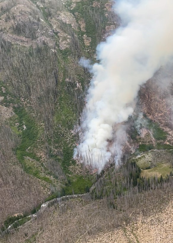
Tuesday, June 24, 2025

6/24/2025 Hot Spring Fire Update


Wildfire near popular BLM hot spring site under investigation
VALE, Ore. – Two Type 2 hand crews and three engine crews are mopping up the Hot Spring Fire 7 miles west of Adrian, Ore., and will continue to monitor the perimeter overnight.
Located on Vale District Bureau of Land Management-protected lands, the fire is burning on the west side of Owyhee Lake Road near the Snively Hot Springs Recreation Site.
Vale BLM Fire crews were dispatched at 1:40 a.m. MT today and reported the fire had spread to 200 acres by 3:35 a.m. Forward progression of the was halted by 12:20 p.m. The fire is currently 25 percent contained at 231 acres.
Vale Rangeland Fire Protection Association and Adrian Rural Fire Protection District assisted with the response. At midday, there were 4 engines, a dozer, 6 aircraft and a rappel team from John Day assigned to the suppression.
A joint investigation by the BLM, Oregon State Police and Office of the State Fire Marshal has determined the fire was human-caused. Witnesses or anyone with information about the fire is asked to call 541-473-6361.
Recent, unseasonably cool weather ended today, with temperatures rising into the 80s this afternoon and potentially reaching 100 by midweek next week.
Members of the public are reminded to keep campfires small and never leave them unattended. Always drown out a fire completely by pouring water on it, stirring with a shovel, and repeating until the fire is cold to the touch.
“Lowering the risk of wildfires is a team effort,” Crouch said. “Thank you for supporting our firefighters and helping to protect our public lands and our local communities.”
The Oregon/Washington BLM Fire Prevention Order prohibits the use of fireworks, tracer, and incendiary ammunition, and exploding or metal targets on public lands. A copy of this order, which will remain in effect through Oct. 31, can be found at https://on.doi.gov/3zs2otL.  
Any and all wildfire starts on public or private land should be reported by calling 911.

6/24/2025 NWCC Morning Brief

Monday, June 23, 2025

6/23/2025 Rowena Fire Update


Sen. Ron Wyden visits the Rowena Fire as containment increases

THE DALLES, Ore. – This will be the last update from the Type 3 team between Mid-Columbia Fire & Rescue, Oregon Department of Forestry, and USFS-Columbia River Gorge National Scenic Area Public Information.

Over the weekend Sen. Ron Wyden visited local officials and the Type 3 team staff to show support and tour the affected area of Rowena before attending a town hall in Hood River, Ore.

Sunday firefighters addressed the few remaining areas of suppression repair while the majority began to demobilize and travel home. In the coming week, the Type 3 team will transition out and hand the fire back to local resources. A plan of action has been formed to meet the remaining containment needs for local resources to patrol and monitor. Interior smoke may be present for several weeks if hidden hotspots emerge under heat or wind.

As a reminder, Wasco County will hold two Multi-Agency Resource Center (MARC) events next week to continue to assist individuals and families who have lost their homes or experienced significant damage due to the Rowena Wildfire. Public, private, and nonprofit organizations will join at the Gloria Center, located at 2505 W 7th St. in The Dalles, to offer a wide range of services and resources. MARC events will be held on Monday, June 23 from 12 to 3 p.m. and Wednesday, June 25 from 4 to 6 p.m. For questions about the MARC, call 541-506-2724.

All evacuations have been lifted by the Wasco County Sheriff’s Office: www.facebook.com/WascoCountySheriff

The Rowena Fire Facebook page will remain open for now. A local Public Information Officer will remain available for further inquiry about the Rowena Fire via this email rowenafire2025info@gmail.com

6/23/2025 NWCC Morning Brief

Friday, June 20, 2025

6/20/2025 NWCC Morning Brief

6/19/2025 Rowena Fire Update


Rowena Fire Daily Update 06-19-2025

Rowena Fire
Publication Type: News - 06/19/2025 - 14:08

Final Fire Update from the ODF IMT

Rowena, Ore. – Today is the last day the Oregon Department of Forestry’s Incident Management Team will be managing the fire. At 6:00PM. this evening, command will officially transition to a local Type 3 team in unified command between Mid-Columbia Fire & Rescue, ODF’s Central Oregon District - The Dalles Unit, and USFS-Columbia River Gorge Scenic Area. The incoming team will continue working toward the same objectives of completing mop up and containment and working on suppression repair.

Hot and windy conditions are expected again today, with gusty winds likely this afternoon and evening.

With the successful work in building strong fire lines and the increase of containment, the Wasco County Sheriff’s Office has lifted all evacuation levels around the Rowena Fire.

Because of the removal evacuation levels, the Red Cross will close the shelter today.

Temporary Flight Restriction (TFR): A “TFR” is in place at an altitude from the surface up to and including 6500 feet, daily (24 hours) until further notice. Complete information is available at https://tfr.faa.gov/tfr3/?page=detail_5_2600. Flying a drone near or around a wildfire compromises the safety of pilots and interferes with firefighting efforts. This restriction will remain in place until 6PM today.

This will be the final update from the ODF IMT. The ODF Incident Management Team sincerely thanks all cooperating agencies and the public for their support throughout this response. We are especially grateful to the local community. Their support played a vital role in our success.


Thursday, June 19, 2025

6/19/2025 Alder Springs Fire Update

Alder Springs Fire Update – June 19, 2025

Central Oregon —Wildland fire crews made great progress on the Alder Springs Fire yesterday, increasing containment and securing the perimeter up to 50 feet around the entire fire. Oregon State Fire Marshal (OSFM) task forces continued their structure protection work in and around Crooked River Ranch. The fire is 3,278 acres and is now 21% contained.

Yesterday crews worked the east flank of the fire from Crooked River Ranch to the Deschutes River continuing mop up and cooling hot spots deeper into the interior of the fire. The Texas Canyon Interagency Hotshot crew has been working hot spots in the steep canyon drainage, supported by helicopters dropping water on areas of more dense heat. Rappelers and smokejumpers focused on mopping up and extinguishing hot spots in the Carcass Canyon area while crews continued securing the perimeter from Whychus Creek north to the confluence with the Deschutes River. OSFM continued working around structures, extinguishing hotspots and conducting tactical patrols near previously threatened homes.

With increased containment and the presence of OSFM task force engines in Crooked River Ranch, the Jefferson County Sheriff’s Office has lifted all Level 3 evacuation orders for the Alder Springs Fire and downgraded zones. Residents are encouraged to visit evacuation maps provided by each county for updated evacuation information. Please use caution returning to homes and neighborhoods because fire resources are still present and working in the area. Access to BLM-administered lands including the Steelhead Falls, Scout Camp and Otter Bench trailheads remains closed.

Today, firefighters will continue containment efforts by increasing mop up to 100 feet around the fire perimeter. While there will still be smoke on the interior of the fire area, crews will spend the day building off yesterday’s success with the assistance of Unmanned Aircraft Systems (UAS) or “drones” that use heat sensing technology to more efficiently find heat close to the perimeter. This will allow firefighters to identify and prevent hot spots from rekindling in hot and windy weather to threaten containment. With the immediate threat decreasing, OSFM has begun scaling back its response and is in the process of demobilizing some task forces, allowing them to return to their home communities. Meanwhile, today’s crews remain on the ground, continuing community surveys and assessing structures for safety and damage. OSFM remains committed to supporting local communities and coordinating efforts statewide as the situation evolves.

Evacuations: The Jefferson and Deschutes County Sheriff’s Offices have changed evacuation levels and there are no longer Level 3 (GO) evacuation orders in place.  For more information on evacuation notices visit:
Deschutes County Evacuation Map: https://tinyurl.com/DeschutesCountyEmergency
Jefferson County Evacuation Map: https://tinyurl.com/JeffersonCountyEmergencyMap


6/19/2025 Pomas Fire Update


Pomas Fire Update

June 19, 2025

Phone: 509-596-1421

Inciweb: https://inciweb.wildfire.gov/incident-information/waowf-pomas-fire-2025

Facebookhttps://www.facebook.com/OkaWenNF

Fire size: 910 acres

Location: Glacier Peak Wilderness, 36 miles northwest of Entiat, WA

Start date: June 13, 2025

Cause: Lightning

Fuels: Dead and down timber


Wenatchee, WA – The Pomas Fire is actively burning in dead and down timber in steep terrain in the Glacier Peak Wilderness. Winds continue to spread the fire which has moved north into Ice Creek and northeast into Aurora Creek just west of Borealis Peak. The fire behavior includes spotting and group tree torching along with active backing and flanking activity.


Fire personnel continue to assess and look for opportunities to use containment lines that were used in past fires in the vicinity. Aviation resources are being utilized as needed. A Temporary Flight Restriction is in effect over the fire area. Please do not fly drones in this restricted air space. Crews will be wrapping key infrastructure, such as the Myrtle Lake bridge, with protective fire-resistant materials over the next few days.


People driving on the Entiat River Road will see an increase in fire personnel on that road, please slow down and drive carefully.


Although the forecast is for cooler temperatures, large amounts of dead timber in the area, west winds, and low humidity with critically low fuel moistures will continue to challenge safe and effective firefighting efforts. 


Smoke: Smoke has been blowing down the Entiat Valley drainage and over into the Lake Chelan area.

Smoke is also visible from Holden Village and Lake Chelan areas as well as the Trinity/Chiwawa area. For more information on smoke and air quality please visit: https://wasmoke.blogspot.com/  


Closures: The Glacier Peak Wilderness on the Entiat Ranger District, including Ice Lakes, is now closed for fire operations and public safety. Mrytle Lake access is also closed. The fire is 12 air miles from the Pacific Crest Trail and currently poses no threat to that trail.


Specific trail closures include:

  • Trail #1400 (ENTIAT RIVER TRAIL)
  • Trail #1404 (COW CREEK TRAIL)
  • Trail #1404A (MYRTLE LAKE TRAIL)
  • Trail #1430A (LARCH LAKE HIKER TRAIL)
  • Trail #1430 (LARCH LAKES TRAIL)
  • Trail #1408 (GARLAND PEAK TAIL) from the saddle south of Fifth of July Mountain to the junction with Trail #1453
  • Trail #1453 (POMAS PASS TRAIL)
  • Trail #1405 (ICE CREEK TRAIL)
  • Trail #1230 (SNOWBRUSHY TRAIL) from the junction with Trail #1400 to Milham Pass
  • Trail #1432 (45 MILE DRIVE TRAIL)
  • Trail #1434 (DUNCAN HILLL TRAIL) from the wilderness boundary to the junction with Trail #1230
  • Trail #1435 (ANTHEM CREEK TRAIL)
  • Trail #1433 (PYRAMID MOUNTAIN TRAIL) from Saska Pass to the junction with Trail #1230
  • Trail #1431 (COOL CREEK TRAIL)
  • Trail #1231 (WILSON CREEK TRAIL)


Evacuations: None, there are no structures or homes threatened at this time. 


Fire Information: Updates will occur when there is significant new information on this Wilderness fire.  

-End-

Pomas Fire in dead timber stands 6-18-2025

Smoke rises from the Pomas Fire in the Glacier Peak Wilderness on June 18, 2025. The fire is burning in dead and down timber from the 2015 Wolverine Fire.

Credit: USDA Forest Service by John Spencer

6/19/2025 NWCC Morning Brief

Tuesday, June 17, 2025

6/17/2025 Rowena Fire Update

6/17/2025 Alder Springs Fire Update

6/17/2025 NWCC Morning Brief

6/16/2025 Rowena Fire PM Update

6/16/2025 Alder Springs Fire Update

6/16/2025 Ferry Fire Update

6/16/2025 Rowena Fire AM Update


Fire Containment Increases as Firefighters Dig Deeper into the Fire

Rowena, Ore. – Last night, firefighters continued to strengthen the fire line using sophisticated handheld infrared devices to search for buried heat below the surface. Today, firefighters will mop up identified hot spots and continue to build depth around the fire perimeter utilizing engines and hand crews. Today’s weather will be slightly cooler, but winds will increase with gusts reaching the mid 40 mph range. 

With the threat to structures diminishing, the OSFM Green Team is demobilizing this morning ending the unified command with the Oregon Department of Forestry’s IMT2. Oregon Department of Forestry’s work continues as IMT2 took sole command of the fire at 6:00 am this morning. Two OSFM task forces and three overhead personnel will remain for ongoing structural mitigation. We’d like to thank OSFM and the Oregon Fire Service for their immediate response to the Rowena Fire, and the continued partnership with Federal, State, and local agencies. The relationships that are built and maintained keep the unified command model a success when responding to Oregon’s emergency situations.   

Level 1, 2 and 3 evacuations remain in effect under the Wasco County Sheriffs Offices direction. You can search for specific addresses here: https://perimetermap.com/wascocounty-or 

The Red Cross shelter remains open at The Dalles Middle School at 1100 East 12th Street. Livestock and horses can be taken to the Wasco County Fairgrounds at 81849 Fairgrounds Road. 

I-84 remains open, however firefighters are continuing to work near the roadway; be aware of crews when driving through the area. 

6/16/2025 Pomas Fire Update


Pomas Fire Update

June 16, 2025

Phone: 509-596-1421

Inciweb: https://inciweb.wildfire.gov/incident-information/waowf-pomas-fire-2025

Facebookhttps://www.facebook.com/OkaWenNF

Fire size: 362 acres

Location: Glacier Peak Wilderness, 36 miles northwest of Entiat, WA

Start date: June 13, 2025

Cause: Lightning

Fuels: Dead and down timber


Wenatchee, WA – Smokejumpers responded to a wildfire first reported by a hiker in the Glacier Peak Wilderness on the morning of June 13th. Throughout the day on Friday, a helicopter and two airtanker scooper planes worked continuously to limit new growth on the Pomas Fire. Inaccessible by road, the fire is burning mid-slope at over 5,000 feet in elevation in heavy dead and down timber from the 2015 Wolverine Fire. While there has been no lightning in the area since late-May, it is not unusual for a strike to smolder for weeks, only becoming visible when the right combination of wind, sun, and drying happens.


Saturday, firefighters continued actively suppressing the fire as well as scouting for natural containment lines, such as rock avalanche chutes, that could be effective at stopping new growth. Up to four scoopers worked the fire, primarily dipping out of Lake Chelan. A helicopter also dipped out of the local Fern and Myrtle Lakes for targeted water drops. Steep terrain will likely limit the ability of air tanker pilots to safely fly the fire area even if retardant were effective in dense timber where typically little, if any, retardant reaches the ground.


Throughout the day Sunday, two helicopters and four airtanker scoopers focused on limiting new growth along the Entiat River. Firefighters successfully used a rocky avalanche chute to hold the Pomas Fire from spreading further down valley toward Mrytle Lake. However, the fire was actively torching in heavy dead and down timber moving towards the Pomas Creek area and spotted across the Entiat River below Borealis Peak late in the afternoon due to winds.   


“This is an extremely tough piece of ground with all the dead and down timber from the 2015 Wolverine Fire and ten years’ worth of thick regeneration,” said Holly Krake, Entiat-Chelan District Ranger for the Forest Service. “The smokejumpers and pilots are doing everything they safely can to keep fire from becoming established on the east side of the Entiat River and down in Snowbrushy Creek.”   


Today, additional firefighters, including two hotshot crews and rappelers, will bolster ground resources to continue suppressing the fire. Scoopers will continue dipping out of Lake Chelan while helicopters will use Fern and Myrtle Lakes for water bucket work. However, heavy dead timber in the area, west winds, and low humidity will continue to challenge safe and effective firefighting efforts. 


“There are four months of significant wildfire potential ahead of us in Central Washington,” added Krake. “While the fire is deep in the Wilderness now, we want to make sure the Pomas Fire doesn’t linger to later threaten communities or tie up firefighting resources in July or August.”  


Smoke: Smoke is visible from Holden Village and Lake Chelan areas as well as the Trinity/Chiwawa area. For more information on smoke and air quality please visit: https://wasmoke.blogspot.com/  


Closures: The Glacier Peak Wilderness on the Entiat Ranger District, including Ice Lakes, is now closed for fire operations and public safety. Mrytle Lake access is also closed. Specific trail closures include Entiat River Trail #1400 past Duncan Hill Trail #1434, Snowbrushy Trail #1230, and Garland Peak Trail #1408. A closure order and map will be posted to Inciweb once they are available. The fire is 12 air miles from the Pacific Crest Trail and currently poses no threat to that trail.


Evacuations: None, there are no structures or homes threatened at this time. 


Fire Information: Updates will occur when there is significant new information on this Wilderness fire.