Tuesday, June 30, 2015

06/30/2015 Central Oregon Evening Update

Contact:  Media Desk:  541-416-6811           Email address:  Centralorfireinfo@gmail.com
Twitter:  @CentralORfire                              For more information visit: CentralORfireinfo.blogspot.com


FIRE NEWS--Central Oregon Interagency Dispatch Center
For Immediate Release:  June 30, 2015 6:00 p.m.


Central Oregon Fire EVENING Update


PRINEVILLE, Ore. – Firefighters on the Corner Creek Fire (formerly Incident #297) continued to be challenged by high temperatures and low relative humidity today which contributed to rapid wildfire growth.

The Corner Creek Fire located 11 miles south of Dayville, Oregon near the Black Canyon Wilderness, experienced significant growth and is estimated to be 2,500 acres with no containment. A VLAT (Very Large Air Tanker), three tankers, 4 SEATs (Single Engine Air Tankers), and three helicopters have been working on structure protection where the fire has threatened cabins and various outbuildings along Wind Creek. The fire is continuing to push south and west burning in light grass and brush.

At 6:00 a.m. tomorrow morning, Oregon Department of Forestry Team 1 will assume command of the Corner Creek, Sugarloaf and #296 fires. The Sugarloaf Fire is still the largest fire in Central Oregon at 5,016 acres and 20% containment. Incident #296 burning about 1 mile south of Dayville grew to about 65 acres. Firefighters are working on containment.

Firefighters were able to respond quickly to lightning start (#283) on the east end of the Maury Mountains east of Prineville this morning, keeping it under ¼ acre. This fire was a “holdover” from lightning storms that have tracked through Central Oregon in the past week. These holdovers can ignite fires up to 2 weeks after the initial lightning strike so fire crews will remain stationed around Central Oregon to respond as quickly as possible to any new fires.

Red Flag Warnings remain in effect through 9 p.m. tonight for lightning, primarily in areas east of Prineville.
  
 -END-

06/30/2015 Buckskin Fire Update

Buckskin Fire

buckskinfire2015@gmail.com


BUCKSKIN FIRE UPDATE - Tuesday June 30, 2015
Cave Junction, Oregon
Fire Location: Rogue River-Siskiyou National Forest
Incident Commander: Monty Edwards
Information Center:541-864-9282/503-784-5656
Inciweb:
http://inciweb.nwcg.gov/incident/4286
Email: Buckskinfire2015@gmail.com

A Type 3 Team led by Incident Commander Monty Edwards is managing control of the Buckskin fire. The Incident Command Post (ICP) is at Wild Rivers Ranger District in Cave Junction.

The Buckskin is estimated at 5,345 acres. Overall containment remains at 60%. Full suppression of this fire remains the operational objective. Today the fire area will be under patrol from the air and a crew will be available for any renewed fire activity or new starts.
The excavators have completed the work of repairing the last areas of the fire. All areas of human degradation around the fire are now returned to as close to a natural state as possible. Trails on or outside the fire line are also repaired.
Firefighters are prepared to Initial Attack (IA) any new starts in the area as well as keeping an eye on the Buckskin.

All helicopters are operating out of Merlin. The Heliwell will be removed tomorrow.
On Thursday a Type 4 team will assume command of the fire and the Type 3 Team will return to their home units.
A Fire Area Closure Order remains in place closing forest land around the wildfire area to provide for public health and safety. For more information, please see the Rogue River-Siskiyou National Forest or Buckskin Fire Inciweb.
Start Date: June 11, 2015 Cause: Lightning
Location: 10 miles southwest of Cave Junction on the Rogue River-Siskiyou National Forest.
Resources:Crews= 3; Engines= 1; Water Tenders= 2; Helicopters= 2.
Total people assigned: 81

06/30/2015 ODF Daily Fire Update

This is an Oregon Department of Forestry (ODF) daily fire update for Tuesday, June 30, 2015.
FIRES ON ODF-PROTECTED LANDS
The lightning-caused Jones Canyon Fire is 500 to 600 acres,burning in the Fossil Subunit of the Central Oregon District, 12 miles NE of Monument. The fire is active and uncontained.

Harper Creek Complex – The complex includes three fires: The largest is the Harper Creek Fire at 320 acres, located four miles south of Mt. Vernon. The Hog Creek Fire is 96 acres, located six miles east of Long Creek. The Luce Creek Fire is 25 acres, located three miles SW of John Day. All are lightning caused and burning in the John Day Unit of the Central Oregon District. Firefighters expect to fully contain the two smaller fires by the end of shift today. The largest fire is 50 percent contained. ODF is gradually releasing firefighting resources from the Harper Creek Complex and reassigning them to the Jones Canyon Fire.
The lightning-caused, 15-acre Happy Ridge Fire reported June 29 burning in the Central Oregon District has been contained and is in mop-up. Air support played a key role in catching the fire at relatively small size.

FIRES ON OTHER LANDS

The lightning-caused Sugarloaf Fireexperienced some growth yesterday and is approximately 5,000 acres. It is burning in the Prineville BLM District north of Dayville and is 20 percent contained. ODF’s Incident Management Team 1 is in command of the suppression operation. 

The 14,600-acre Jaca Reservoir Fire burning 87 miles south of Vale on Bureau of Land Management lands is 40 percent contained. Cause is under investigation. More info:http://gacc.nifc.gov/nwcc/information/fire_info.aspx

The 248-acre Jones Canyon Fire burning 20 miles SW of Ukiah on is uncontained. Cause is under investigation. More info:http://gacc.nifc.gov/nwcc/information/fire_info.aspx

The 639-acre Little Basin Fire burning in the Hells Canyon National Recreation Area, Wallowa-Whitman Nat’l Forest, is 97 percent contained. Cause is under investigation. More info:http://inciweb.nwcg.gov/incident/4290/

The lightning-caused, 5,345-acre Buckskin Fire burning on the Rogue River-Siskiyou National Forest is 60 percent contained. More info:http://inciweb.nwcg.gov/incident/4286/

The lightning-caused, 320-acre Bunker Hill Complex burning 30 miles SE of Oakridge on the Willamette National Forest is 30 percent contained. More info:http://gacc.nifc.gov/nwcc/information/fire_info.aspx

The lightning-caused, 4,000-acre Leslie Gulch Fire burning 45 miles south of Vale on Bureau of Land Management lands is uncontained. More info:http://gacc.nifc.gov/nwcc/information/fire_info.aspx

The lightning-caused, 300-acre Candy Kid Fire burning on Bureau of Land Management lands eight miles north of Drewsy is uncontained. More info:http://gacc.nifc.gov/nwcc/information/fire_info.aspx

The lightning-caused, 300-acre OR-OCH-000297 Fire burning 11 miles south of Dayville on National Forest lands is uncontained. More info:http://gacc.nifc.gov/nwcc/information/fire_info.aspx

06/30/2015 Sleepy Hollow Fire Community Meeting Tonight


Community Meeting for Sleepy Hollow Fire Tonight

Sleepy Hollow Fire community meeting is scheduled for 7 p.m. tonight (June 30) at Foothills Middle School, 1410 Maple Street, Wenatchee. 

The meeting is meant to explain ongoing fire suppression activities and answer public questions. It will be conducted by representatives of the WA State Incident Management Team 2 based at Cashmere. The meeting will include the agencies involved in fighting the fire and protecting public safety. 

There will be discussion of fire suppression tactics, expected weather, and fire mapping. Following the briefings, there will be breakout sessions to answer public questions.

Sleepy Hollow Fire Information: 509-782-1794

06/30/2015 Sugarloaf Fire Update

FOR IMMEDIATE RELEASE
CENTRAL OREGON NEWS MEDIA
Oregon Department of Forestry
Incident Management Team 1
John Buckman, Incident Commander
Contact: Brian Ballou, Information Officer, (541) 621-4156
FIRE AT A GLANCE
DAY SHIFT
5,016 acres
20 percent contained
Lightning-caused

Resources:
7 crews
12 engines
2 bulldozers
2 water tenders
232 personnel
The Sugarloaf Fire is expected to burn more intensely today. The moisture from Sunday’s thunderstorms has dissipated, resulting in drier fuels and lower relative humidity. The amount the fire spreads will be largely influenced by winds and topography. The primary fuels inside the fire perimeter are grasslands and juniper trees in the low country and pine and fir stringers on the upper slopes. This lightning-caused fire covers 5,016 acres and is 20% contained. There are 232 persons assigned to day shift on the fire.
On Monday, progress was made on extinguishing areas around structures on Dick Creek Road. Helicopters were used to cool an area with steep slopes and heavy fuels above Johnny Creek on the north edge of the fire. Dozers worked on creating and improving fuel breaks along the north and east edges of the fire.
Steep slopes and limited access are restricting the suppression efforts on several areas of the fire. Due to steep, broken terrain, fire lines are being dug by hand along parts of the northeast and south edges of the fire. Unburned pockets of fuel inside the current fire area also continue to burn. Engines are patrolling the perimeter roads and the Dick Creek Road to extinguish hot spots near structures. Approximately 12 structures in the Dick Creek Road area were threatened by the fire.
Yesterday this fire team assumed command of a new fire that started to the west of the Sugarloaf Fire. The Blue Basin Fire burned about 400 acres east of State Route 19, largely within the John Day Fossil Beds National Monument. Fire personnel will be working to control this fire without damaging the special resources in the Monument. This is a human caused fire, under investigation.
The Oregon Department of Forestry’s Incident Management Team 1 assumed command of the Sugarloaf Fire at 6:00 a.m. yesterday. The team is working for the Bureau of Land Management, the John Day Fossil Beds National Monument and ODF’s Central Oregon District. The fire is located approximately 8 miles north of Dayville. This incident is being managed as a full suppression fire. Efforts are being made to contain the fire and minimize private acreage burned.
Sensitive sites within the fire area include nationally recognized fossil beds, anadromous fish spawning beds and golden eagle nesting sites. Firefighters are using care to minimize suppression impacts in these areas while they take the actions necessary to contain the fire.
Hazards confronting firefighters include rattlesnakes, lightning, and hot, dry weather. High winds around thunderstorms may cause erratic fire behavior and rapid movement.
Information about the Sugarloaf Fire is posted online at www.centralorfireinfo.blogspot.com.

06/30/2015 Central Oregon Morning Update

Contact: Media Desk: 541-416-6811
Twitter: @CentralORfire
For more information visit: CentralORfireinfo.blogspot.com
FIRE NEWS--Central Oregon Interagency Dispatch Center
For Immediate Release: June 30, 2015 a.m. 

Central Oregon Fire MORNING Update

PRINEVILLE, Ore.– Fire crews continued to work on several fires burning around Central Oregon and firefighters remain vigilant for any holdover fires from the lightning storms that moved through the area last weekend and early this week. . Ten new fires were reported yesterday, with two growing larger.

The largest of the new fires is incident the Corner Creek Fire (Incident #297), burning 11 miles south of Dayville, Oregon near the Black Canyon Wilderness. The fire, burning in light grass and brush, grew to 850 acres overnight. In addition to firefighters on the ground, suppression efforts will be helped by heavy airtankers, single engine air tankers (SEATs) and helicopters today. Firefighters will be challenged today by high daytime temperatures and steep slopes with limited access. The cause is lighting.

The second fire, Incident #296, burning about 1 mile south of Dayville grew to about 65 acres yesterday. The Type 2 team currently managing the Sugar Loaf Fire has assumed command of this incident (Note: Sugar Loaf is two words).

The largest fire in Central Oregon is the Sugar Loaf (incident #268), which continues to be managed by a Type 2 Incident Management Team. Information on Sugar Loaf will be provided on Inciweb at http://inciweb.nwcg.gov/
As temperatures increase through the week, firefighters expect more lightning holdover fires. These fires occur when lightning strikes a tree and starts a fire that smolders in the needles and debris underneath the tree where it’s protected from any rain that falls. As temperatures increase and nearby ground dries out, the fire flares up and can spread. Holdover fires commonly occur up to two weeks after a storm. 

With the potential for fighters to be busy with lightning fires, fire officials want to remind everyone to be extremely cautious with fireworks, and to use care when recreating on public land. Make sure campfires are allowed, and always put them out when you leave or before you go to bed. Avoid traveling on roads with vegetation down the middle – this can accumulate underneath a vehicle and cause it to catch fire.

06/30/2015 Paradise Fire Update

Paradise Fire Update
June 30, 2015
For Immediate Release
360-797-5366
It was a fairly calm day on the Paradise Fire, as crews took advantage of favorable weather conditions. Remote cameras stationed in the Queets River valley transmitted photos back to the Incident Command Post showing smoke concentrated in a few areas of the fire perimeter.

Of particular concern to firefighters is the area around Paradise Creek on the flanks of Pelton Peak. A return to higher temperatures are expected later this week, so weather conditions will again challenge firefighters.
One of the Incident Management Team’s priority objectives is firefighter safety. This is a particular point of concern today, which is the second anniversary of the Yarnell Fire near Prescott Arizona, where 19 members of the Granite Mountain Hotshot crew lost their lives. Tragedies like this are a constant reminder of the need to be vigilant and alert to safety hazards. The Paradise Fire is burning in very steep terrain, and fire managers continue to assess safety conditions in order to avoid putting firefighters at risk.
Park crews responded to an illegal escaped campfire late Monday. The public is reminded that conditions remain extremely dry, and the forest is vulnerable to careless human caused fires. With the 4thof July weekend approaching, the public needs to be even more vigilant.
Olympic National Park has instituted a ban on open fires in the park’s wilderness backcountry, including all locations along the coast. Campfires are permitted only in established fire grates at established front country campgrounds. The burn restriction will remain in place until further notice. Camp stoves may still be used in the park's wilderness backcountry, but should be operated well away from flammable vegetation and forest litter. Because of the extreme conditions on the peninsula, Olympic National Forest has also implemented fire restrictions. 

Information on this fire is available on Inciweb at http://inciweb.nwcg.gov/incident/4305/. For real time information, visit our Facebook page at: https://www.facebook.com/pages/Paradise-Fire/831205013596015. For current information about visiting Olympic National Park, as well as information about the history and role of fire in the Olympic ecosystem, please visit the park’s website at http://www.nps.gov/olym.

06/29/2015 Central Oregon Evening Update

Contact:  Media Desk:  541-416-6811           Email address:  Centralorfireinfo@gmail.com
Twitter:  @CentralORfire                              For more information visit: CentralORfireinfo.blogspot.com

FIRE NEWS--Central Oregon Interagency Dispatch Center
For Immediate Release:  June 29, 2015 8:00 p.m.
 
Central Oregon Fire EVENING Update


PRINEVILLE, Ore. – Firefighters are continuing to respond to several fires across Central Oregon tonight, the largest fire is 100 acres on the southeast border of Black Canyon Wilderness with no containment at this time.

As afternoon winds picked up, firefighters engaged numerous fires on and near the Ochoco National Forest and Prineville BLM. The second largest wildfire of the day is Incident #296, which was originally reported at 30 acres 1 mile south of Dayville, Oregon. Several engines and single engine air tankers are working to stop forward progress at the head of the fire and protect structures.  

Crews also responded to a 7 acre fire 4 miles west of Mill Creek Wilderness that has been lined by firefighters who have progressed into mop-up.

The largest fire in the area is still Sugarloaf (incident #268), which remains at 4,612 acres. Crews continue to make progress constructing a fireline and the incident remains 20 percent contained.  The fire is located about 8 miles north of Dayville, OR and is burning in a combination of shrub and light grass. This incident also absorbed a new start outside of the fire area immediately north of John Day Fossil Beds National Monument. No further information on this incident is available this evening.
  
All other starts, including two on the Deschutes National Forest, have been held to under half an acre.

-END-

Monday, June 29, 2015

06/29/2015 Sugar Loaf Fire Update


Oregon Department of Forestry
Incident Command Team 1
John Buckman, Incident Commander

FIRE AT A GLANCE

DAY SHIFT
4,612 acres
20 percent contained
Lightning-caused

Resources:
6 crews
20 engines
3 bulldozers
2 water tenders
203 personnel
Contact: Brian Ballou, Information Officer, (541) 621-4156

The Oregon Department of Forestry’s Incident Management Team 1 assumed command of the Sugarloaf Fire at 6:00 a.m. today. The team is working for the Bureau of Land Management, the John Day Fossil Beds National Monument and ODF’s Central Oregon District.
The fire is located approximately 8 miles north of Dayville. The Sugarloaf Fire’s incident command post is located at the Dayville School.
A few rain showers associated with a passing thunderstorm have slowed fire activity this morning, but much work remains to be done to contain the Sugarloaf Fire. The primary vegetation fuels inside the fire perimeter are grasslands and juniper trees in the low country and pine and fir stringers on the upper slopes.
The greatest fire activity is along the northeast flank of the fire, and the south and southwest flanks are relatively cool.
This incident is being managed as a full suppression fire. Efforts are being made to contain the fire and minimize private acreage burned. Fireline construction continues along the north flank. Engines are patrolling the perimeter roads and the Dick Creek Road, which cuts through the middle of the burned area, to extinguish hot spots near structures.
Approximately 12 structures in the Dick Creek Road area were threatened by the fire and some residents left the area on Sunday. Residents have since returned home. No primary structures burned.
A Red Flag Warning remains in effect for the fire area today. Thunderstorms may develop again through the afternoon and bring scattered showers. Wind is expected to be 10 mph from the northwest, but may be stronger and gustier around thunderstorms.
Sensitive sites within the fire area include nationally recognized fossil beds, anadromous fish spawning beds and golden eagle nesting sites. Firefighters are using care to minimize suppression impacts in these areas while they take the actions necessary to contain the fire.
Hazards confronting firefighters include rattlesnakes, lightning, and hot, dry weather. High winds around thunderstorms may cause erratic fire behavior and rapid movement.
Information about the Sugarloaf Fire is posted online atwww.centralorfireinfo.blogspot.com.
###

06/29/2015 Buckskin Fire Update

BUCKSKIN FIRE UPDATE - Monday June 29, 2015
Cave Junction, Oregon
Fire Location: Rogue River-Siskiyou National Forest
Incident Commander: Monty Edwards
Information Center: 541-864-9282/503-784-5656
Inciweb: http://inciweb.nwcg.gov/incident/4286
Email: Buckskinfire2015@gmail.com

A Type 3 Team led by Incident Commander Monty Edwards is managing control of the Buckskin fire at 0600. The Incident Command Post (ICP) is at Wild Rivers Ranger District in Cave Junction.

The Buckskin is estimated at 5,345 acres. Overall containment remains at 60%. Full suppression of this fire remains the operational objective. Today the fire area will be under patrol from the air and a crew will be available for any renewed fire activity or new starts. Two Excavators continue working to complete rehabilitating firelines, safety areas, drop points, trails and turnouts have completed their work.
Firefighters are prepared to Initial Attack (IA) any new starts in the area as well as keeping an eye on the Buckskin.

All helicopters are operating out of Merlin. The Heliwell will be going away today.
A Fire Area Closure Order remains in place closing forest land around the wildfire area to provide for public health and safety. For more information, please see the Rogue River-Siskiyou National Forest or Buckskin Fire Inciweb.
Start Date: June 11, 2015 Cause: Lightning
Location: 10 miles southwest of Cave Junction on the Rogue River-Siskiyou National Forest.
Resources: Crews= 4; Engines= 1; Water Tenders= 2; Helicopters= 1.
Total people assigned: 106

06/29/2015 NW lightning map from 8 a.m. June 28 to 8 a.m. on June 29


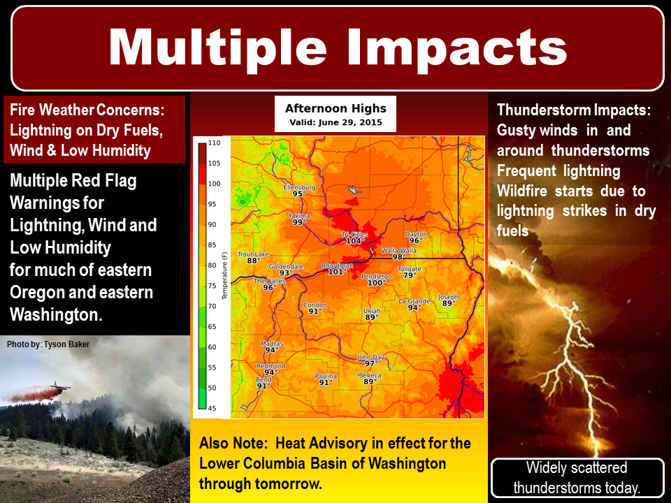
6/29/2015 Fire Weather Concerns and Impacts


gfgf

Embedded image permalink

06/29/2015 Paradise Fire A.M. Update


Paradise Fire Update  
June 29, 2015

For Immediate Release
360-797-5366*** Note New Information Phone Number


Crews on the Paradise Fire reported moderating weather and limited fire growth on Sunday, a change from the previous several days of high temperatures and low relative humidity. While other parts of the Pacific Northwest experienced lightning and thunderstorms, only intermittent sprinkles fell on the fire area. A smoke inversion also contributed to a quieter day.

Yesterday's highlight for fire crews camped out in the Queets River drainage was the delivery of a satellite communications unit. This will allow the firefighters to keep in closer contact with fire management officials at the Incident Command Post in Port Angeles. The unit improves safety conditions by giving the crews access to maps and creates more secure communications links in the event of an illness, emergency, or other situation that requires increased coordination of fire management activities. It also provides a convenience of telephone and internet contact with the outside world.

Yesterday's milder weather conditions will be repeated for the next two days as a high pressure system breaks down and is replaced by an upper level low that should last until Tuesday. However, high temperatures and increased fire potential return mid-week and are expected to remain through the upcoming 4th of July holiday weekend. Crews will continue their work to confine the fire north of the Queets River.

Olympic National Park has instituted a ban on open fires in the park's wilderness backcountry, including all locations along the coast. Campfires are permitted only in established fire grates at established front country campgrounds. The burn restriction will remain in place until further notice. Camp stoves may still be used in the park's wilderness backcountry, but should be operated well away from flammable vegetation and forest litter. Because of the extreme conditions on the peninsula, Olympic National Forest has also implemented fire restrictions.  

Information on this fire can be obtained on Inciweb at http://inciweb.nwcg.gov/incident/4305/, and by calling Paradise Fire Information at 360-565-2986. For real time information, visit the Paradise Fire Facebook page at: https://www.facebook.com/pages/Paradise-Fire/831205013596015.
For current information about visiting Olympic National Park, as well as information about the history and role of fire in the Olympic ecosystem, please visit the park's website at http://www.nps.gov/olym

06/29/2015 NWCC Large Fire Brief

Morning Brief

Date/Time Stamp: Monday, June 29, 2015: 0730 Correction (Number of NW new large fires)

Activity Summary

In the Northwwest:
Lightning received over much of Oregon and Washington. Five new large fires. Two additional IMT deployments: T1 ODF Team 1 (Buckman) to Sugar Loaf and T2 WA Team 2 (Rabe) to Sleepy Hollow.

Preparedness Levels

Current:

Northwest

3 (no change)


National

3 (no change)


Northwest PL Forecast:

4

3

3


3-day

10-day

30-day


Northwest Fire Activity

Large Fire Summary
New large fires: 5
Large fires contained: 0
Uncontained large fires: 10 (OR: 6, WA: 4)
New Fires and Acres: 41 fires for 9,964 acres
(1,217 acres growth on existing large fires)
OR: 29 fires for 3,959 acres
WA: 12 fires for 6,005 acres

Northwest IMT Activity

Area Command Teams committed: 0
NIMOs committed: 1
Type 1 IMTs committed: 1
Type 2 IMTs committed: 2


National Fire Activity

Initial attack activity: Light (177 new fires)
New large incidents: 46
Large fires contained: 0
Uncontained large fires: 25

National IMT Activity

Area Command Teams committed: 0
NIMOs committed: 1
Type 1 IMTs committed: 1
Type 2 IMTs committed: 12


Current Incident Details

Incidents not Previously-Reported: 5
Sleepy Hollow WA-WFS-000518. 0.25 mi N of Wenatchee, WA. Start 6/28. Full Suppression. Grass/Brush. Extreme fire behavior. 3,000 acres. Multiple structures lost. IMT2 WA Team 2 (Rabe) is mobilizing to the incident.
Saddle Lake WA-MCR-000283. ICT3 25 mi SW of Othello, WA. Start 6/28. Full Suppression. Grass/Brush. Extreme fire behavior. 3,000 acres.
Jaca ReserviorOR-VAD-000059. ICT3. 87 miles S of Vale, OR. Start 6/28. Full Suppression. Grass/Brush. Cause lightning. 1,500 acres. Active fire behavior. Limited information available.
Leslie GulchOR-VAD-000062. ICT3. 45 miles S of Vale, OR. Start 6/28. Full Suppression. Grass/Brush. Cause lightning. 1,500 acres. Active fire behavior. Limited information available.
Harper OR-952S-15114. 8 miles SW of John Day, OR. Start 6/28. Full Suppression. Grass/Timber. Cause lightning. 700 acres. Active fire behavior. Limited information at this time.
Incidents Previously-Reported: 5
0268 PRD Sugar Loaf OR-PRD-000268. IMT1 ODF Team 1 (Buckman). 9 miles N of Dayville, OR. Start 6/27. Full Suppression. Brush/Grass/Timber. Cause Unknown. 5,500 acres (-505). 20% containment. Active fire behavior. Residences evacuated. One outbuilding destroyed.
Bunker Hill Complex OR-UPF-201556. IMT2 OR Team 2 (Fillis). 30 miles SE of Oakridge, OR. Start 6/26. Full Suppression. Timber. Cause lightning. 167 acres (+17). 10% containment. Moderate fire behavior. Includes Bunker Hill fire and 6 Misc ABC fires totaling 20 acres. Previously listed as Bunker Hill.
SE Benton Complex WA-WFS-15-2435. IMT3. 15 miles SE of Kenniwick, WA. Start 6/27. Full Suppression. Grass. Cause Unknown. 2,400 acres (+1,200). 50% containment. Active fire behavior.
Paradise WA-OLP-000005. NW NIMO (Hahnenberg). 33 mi SE of Forks, WA. Start 6/15. Confine.Timber. 1,025 acres (+0). 20% containment. Cause lightning. Moderate fire activity with backing and creeping fire behavior observed.
Buckskin OR-RSF-000382. IMT3. 10 miles SE of Cave Junction, OR. Start 6/11. Full Suppression. Timber. Cause lightning. 5,345 acres (+0). 60% containment. Minimal fire behavior. Area closures in effect.

Northwest Fire Potential Summary:

Today should spell the last day of significant lightning across the region with the main focus being in eastern Washington with a lesser chance in western Washington and extreme northern portions of Oregon. Strong high pressure will rebuild by Wednesday for another hot and dry week. After today, IA should begin to drop back to normal. However burning conditions will remain elevated due to dry and unstable conditions with likelihood of another thermal trough forming over the Cascades as we progress into the week.

National Incident Management Situation Report (IMSR): http://www.nifc.gov/nicc/sitreprt.pdf

Other GACC Morning Reports